We are happy to announce that doctoral candidate Daniel Romm, along with colleagues, has just published a peer-reviewed, open-access article in the Journal of Cycling and Micromobility Research. In The Cars are Going to be Alright: Examining Micromobility Infrastructure Space Allocation and Potential Improvement Scenarios in Montréal, the team explores how street space is currently divided among cars, bicycles, and other modes, and models what happens when we reallocate more room to micromobility users.
Using a novel Equal Infrastructure Allocation (EIA) score, Romm and co-authors quantify the imbalance of street space per traveller, borough by borough, in Montréal. They then simulate scenarios with dramatically increased micromobility infrastructure to see how (or if) this actually shifts the balance.
They find:
Equal Infrastructure Allocation Score: Provides a transparent metric for planners to communicate trade-offs with micromobility infrastructure projects.
Persistent Car Dominance: Even large-scale improvements to micromobility lanes have only a minor effect on the total space cars occupy.
Streets for Cars
Since the early 20th century, cities in Canada, the United States, and globally have been reshaped around the automobile. Among the most confronting aspects of this transformation is the loss of street space for pedestrians, bicyclists, and urban life, as roadways have come to dominate the urban landscape. The cost of molding the city to the figure of the car is steep, and today there is a growing awareness of the harms of what has been called “automobility”, which range from CO2 pollution, to fatalities from car crashes, risks to the health of drivers, and the erosion of public and community spaces.
Cities now have been experiencing movements trying to change the car-dominated reality of our cities, including “complete streets” projects, “Vision Zero” policies, and COVID-19 era street redesigns. In Canada, the Federation of Canadian Municipalities (FCM) released a COVID-19 street rebalancing guide, and cities have shifted space away from car infrastructure in favour of pedestrians, cyclists, and urban life.
The growth of cycling and other forms of micromobility, especially through sharing systems, has been part of the changing urban streetscape, involving calls for improving dedicated micromobility infrastructure, such as separated bike lanes. Yet, efforts to do so are routinely met with fierce backlash, in a phenomenon that has been called “bikelash”.
Montréal, known amongst its North American peers as a (relatively) prominent cycling city, has long had a cycling culture and is now undertaking to expand its more than 900 km of cycling infrastructure. Still, even in Montréal, bike lane projects are frequently met with protest. In this inflammatory environment, and with the recognition of the pressing need to change our streets, how then are cities to move forward with street redesign projects?
Space Matters
This fight over the shape of the street is, in essence, a conflict about public space: who its designed for, who its used by, and who has the right to it. When protests erupt over the introduction of a bike lane, it is the subtraction of space from cars that so enervates drivers. But, of course, one of the key advantages of micromobility is revealed in the first part of the term – it is “micro” – relative to the car, micromobility asks for little space. In fact, if you were to add all the space dedicated to bike lanes in Montréal – would it even be a sliver of the space given over to cars?
In 2013, this question about the space allocated to different transport infrastructures was put forward in a popular blog post, which drew over images of streets to demonstrate the way street space was dominated by car space. Later in the 2010s, researchers began to investigate street space allocation scientifically, digitizing satellite imagery, manually measuring streets, or using already-prepared digital datasets offered by public agencies. These studies have found, across the world, that street space is – overwhelmingly – allocated to car infrastructure.
If this is the case, if cars already have so much space to move in cities, proportionally, why are drivers so reluctant to sacrifice even a little of this space? Despite already owning the street, drivers still feel pressed for space. In Montréal, a “cycling city” – are they?
Measuring Montréal
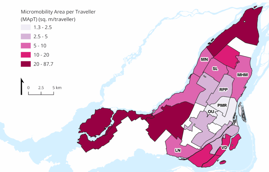
Compiling a swath of data sources, we measured how street space was allocated, borough by borough, across Montréal, and also how street space allocation related how people travelled in the city. In Montréal, there is 42.76 km2 (79.60%) of car infrastructure, 4.17 km2 (18.83%) of pedestrian infrastructure, and 1.02 km2 (1.57%) of dedicated micromobility infrastructure. Micromobility infrastructure takes an incredibly small amount of space on Montréal’s streets.

If we only consider the balance between car infrastructure and micromobility infrastructure, the portrait is more dire: cars have 97.68% of the roadway, and micromobility only 2.32%. In contrast, of trips using these modes, 95.08% use the car and 4.92% use micromobility, demonstrating a 212% discrepancy. The borough with the greatest proportion of the roadway allocated to micromobility is Le Plateau-Mont-Royal (PMR), with only 4.65% of street space for dedicated micromobility infrastructure, closely followed by Rosemont-La Petite-Patrie (RPP), at 4.62%. Yet, Le Plateau-Mont-Royal has 21.9% of trips the start in that borough using micromobility, and Rosemont-La-Petite-Patrie has 9.97%. There is a massive discrepancy between the proportion of micromobility travellers, and the infrastructure space dedicated to them.
If we calculate the space per traveller (in terms of square meters), we find that car travellers are given 5.8 m2/traveller, while micromobility travellers are given 4.54 m2/traveller. In Le Plateau-Mont-Royal, the most popular borough for cycling, micromobility travellers are only given 1.51 m2 per traveller, compared to 3.36 m2 for drivers.

The measure of space per traveller is fairly intuitive, but to better capture the relationship between the two, we can use the novel Equal Infrastructure Allocation measure (EIA), which simply measures the relational proportion between micromobility and automobile infrastructure, relative to traveller counts (micromobility area per traveller minus automobile area per traveller, divided by automobile area per traveller). When EIA is 0, infrastructure allocation is considered equal between the two modes; when it is below 0, it is biased in favour of the automobile. This novel indicator finds 9 (of 19) boroughs in Montréal with a score below 0, meaning that there is inequality in spatial allocation per traveller in favour of cars. Le-Plateau-Mont-Royal is among the worst in these terms, with an EIA score of -0.55.
What if we built a lot of micromobility infrastructure?
Given the degree to which street space in Montréal is allocated to cars, is there really a need to worry about car space? There is anger over the addition of a single bike lane – how much space does this really take? Street space allocation measures can be used to model these scenarios.
Montréal’s BIXI bikeshare system has more than 11,000 bikes and 900 stations, as of April 2024. What if we took a really radical approach, and doubled the capacity of this system – 22,000 bikes over 1800 stations? The total space used by the BIXI system is only 0.021 km2. Doubling this only reduces the amount of automobile space by -0.003m2/traveller. Micromobility sharing infrastructure takes very little space. Though Montréal’s micromobility sharing system is station-based (docked), “dockless” systems are often derided over perceptions of their disorderly use of space. There are solutions to better organize stationary dockless vehicles, including “virtual docks”, and the use of typical bike racks and corrals, that have been found effective in improving parking compliance. As we can see through this modelling, there is more than ample space available for these installations, without substantially affecting the space allocated to automobiles.
What if we took a more radical approach, and doubled all the bikelanes in Montréal? The micromobility area would increase by +4.447m2/traveller, and the car area would only decrease by -0.135m2/traveller. In Le-Plateau-Mont-Royal, drivers would lose just -0.154m2/traveller. The EIA score would improve by +0.804, with all but two boroughs having a positive EIA. Even then, the proportion of automobile area of the roadway never falls below 90%. While the picture for micromobility improves dramatically, there is almost no discernable effect on automobile area per traveller. Proportionally, automobiles will still dominate spatial allocation.
This demonstrates a disproportional benefit provided by micromobility infrastructure projects, where changes to micromobility area can significantly improve matters for micromobility travellers while minimally affecting automobile area.
Changing Our Streets
Backgrounded by climate change, traffic fatalities, the growing popularity of micromobility, and a realization that the form of the modern street is actively harmful, cities find themselves at an inflection point, with the opportunity to reshape their mobility landscape. In effect, there is increasingly widespread agreement about the direction of desirable change: away from automobility. Yet, planners, policy makers, and advocates face entrenched opposition to any policies which engender the system and structure of automobility, including street space reallocation. Cases of “bikelash”, even for modest micromobility infrastructure proposals, demonstrate this well.
We’ve introduced the measure of Equal Infrastructure Allocation (EIA), to assess and clearly communicate the provision of micromobility infrastructure, relative to automobile infrastructure. This measure, alongside those of dedicated micromobility infrastructure area per traveller and automobile infrastructure area per traveller, can be used to illustrate the effects of future infrastructure scenarios on spatial allocation. EIA is intended to assist planners, policy makers, and advocates with communicating about reallocation proposals with the public.
Perhaps with its use and the use of other tools developed in street space allocation studies, it can be made evident that even with micromobility infrastructure improvements at a scale dramatically larger than anything now proposed, such as doubling all existing dedicated micromobility lanes, street space allocation remains biased in favour of cars; such is the extent of the current domination of automobility.
With most micromobility infrastructure improvement proposals we see today, comparatively little space will be taken from the automobile, so drivers need not worry – the cars are going to be alright.

